
-
Community & Family Services
- Care Management Program
- Child Support Enforcement Unit
- Family Support
- HCBS Waiver
- Home Improvement Supplement Program (HIP)
- Homeowner's Assistance Fund
- Individual Residential Alternatives (IRA)
- Individual Supports and Services (ISS) - Housing Subsidy Program
- Office of the Family Advocate
- Three Sisters Program
- Tribal Vocational Rehabilitation (TVR)
- Community Partnership Fund
- Economic Development
- Education
- Environment
- Executive Director's Office
- Finance
- Generations Park
- Grants & Contracts
-
Health Services
- A/CDP Outpatient
- A/CDP Prevention
- Partridge House (Inpatient)
- Ronthahiiohsthá:ke Clubhouse
- Business Office
- Dental Clinic
- Health Promotion and Planning
- Laboratory
- Diabetes Center for Excellence
- Medical Clinic
- Mental Health - Kanikonri:ihne (Good Mind Counseling)
- Outreach Chronic Care Nursing
- Pharmacy
- School-Based Health Center
- Home Improvement Supplement Program (HIP)
- Human Resources
- Office for the Aging
- Office of Emergency Management and Safety
- Planning and Infrastructure
- Social Services Division
- Tribal Historic Preservation Office
- Saint Regis Mohawk Tribal Police
Wetlands
Water Resources Program
Our Mission
- The mission for the wetland section of the Water Resources Program is to restore, manage, and create wetlands that support culturally significant environments.
What is a Wetland?
- A wetland is an area that is inundated or saturated with water and potentially has standing water for at least a portion of the year.
- To be considered a wetland, an area must have the three wetland indicators present: hydric soils, wetland hydrology, and wetland vegetation.
- For more information on the three indicators and how they are used to determine if a wetland is present visit https://www.dec.ny.gov/docs/wildlife_pdf/wdelman.pdf
- Wetlands act as buffers for watersheds as they absorb nutrients and contaminants from runoff or groundwater that would eventually reach the watershed if the wetland were not present. For this reason, wetlands are known as the kidneys of a landscape because they filter water before it goes into the watershed.

Types of Wetlands
- Marshes
- Swamps
- Bogs
- Fens
https://storymaps.arcgis.com/stories/7a949dca7a644b2e9fef3a2298b4efd1
Marshes
- Marshes are wetlands that are frequently or continually inundated with water and are characterized by soft-emergent vegetation that is adapted to saturated soil condition.
- Marshes recharge groundwater supplies and provide water to streams, which is an important function during drought periods.
- During floods, marshes can reduce damage by slowing down and storing the flood water.
Non-Tidal vs Tidal Marsh
- Non-tidal marshes are usually freshwater marshes (sometimes brackish water) that occur along streams in poorly drained depressions and in shallow water along the boundaries of lakes, ponds, and rivers.
- Non-tidal marshes are highly organic with mineral rich soils. Due to their high levels of nutrients, non-tidal marshes are very productive ecosystems.
- Tidal marshes are either freshwater, brackish, or saline marshes that are influenced by the ocean tide.
- Tidal marshes serve as buffers from stormy seas, reduce shoreline erosion, and absorb nutrients before they get into the ocean.
Swamps
- Swamps are any wetlands that are dominated by woody plants.
- Swamps have saturated soils during the growing season and standing water at certain times of the year.
- Swamps serve as flood protection, and they remove nutrients from watersheds. The trees grown in swamps are useful for building material.
Bogs
- Bogs are characterized by spongy peat deposits, acidic waters, and a thick layer of sphagnum moss covering the wetland floor.
- Bogs receive most of their water from precipitation, which results in low nutrient loads in this type of wetland. Acid forming peat mosses reduce nutrients even more which results in very few plant species being able to grow in the wetlands.
- Bogs reduce flooding by absorbing precipitation.
Fens
- Fens are peat-forming wetlands that receive nutrients through groundwater.
- Fens differ from bogs because they are less acidic and can support more species of fauna and flora.
- Fens provide benefits such as reducing flood risks, improving water quality, and providing habitat for wildlife.
Local Medicinal Wetland Flora (Plants)
https://storymaps.arcgis.com/s...
- Common name: Black Currant Genus: Ribes Species: americanum
Medicinal uses: Root-bark tea is used to expel worms and for kidney ailments; poultice root-bark for swelling. Roots used in infusion, bark used in gargles for eruptive fevers. The fruits and jelly are used for sore throats.
- Common name: Red Maple Genus: Acer Species: rubrum
Medicinal uses: Inner bark tea used for coughs, diarrhea, and diuretic issues. The inner bark tea is known as a “blood purifier”. Maple syrup is used to cleanse the liver and kidney.
- Common name: Crested Shield Fern Genus: Dryopteris Species: cristata
Medicinal uses: Root tea traditionally used to induce sweating, clear chest congestion, and expel intestinal worms.
- Common name: Green Ash Genus: Fraxinus Species: pennsylvanica
Medicinal uses: Inner bark is scraped and made into tea for general fatigue and depression. Leaves are rubbed on insect bites to reduce swelling.
- Common name: Black Ash Genus: Fraxinus Species: nigra
Medicinal uses: The inner bark is soaked in warm water; the combination is used to treat sore eyes.
Local Wetland Fauna (Animals)
https://storymaps.arcgis.com/s...
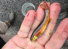
Fish:
- Minnows
- Dace
- Shiners
- Stickleback
- Pumpkinseed
Reptiles/Amphibians:
- Blanding’s turtle
- Common snapping turtle
- Eastern painted turtle
- Wood turtle
- Spotted salamander
- Blue spotted salamander
- American bullfrog
- Green frog
- Wood frog


Birds:
- Osprey
- Red-winged blackbird
- Belted kingfisher
- Great blue heron
- Snowy egret
Mammals:
- Beaver
- Mink
- Otter
- Fisher
- Muskrat
Macroinvertebrates
- A macroinvertebrate is a small organism without a backbone that are visible to the naked eye.
- Examples of local macroinvertebrates that live in wetlands are:
- Stonefly (adult and larvae)
- Mayfly (adult and larvae)
- Dragonfly (adult and larvae)
- Crayfish
- Leech
- Macroinvertebrates are useful water quality indicators for wetlands because they spend their entire lives in the same wetland. Studying the lifecycle of macroinvertebrates and how healthy and long they live for can help determine how healthy a wetland is.
Invasive Species
- What is an invasive species? Any species is not native to an area yet establishes a population there. Usually invasive species have serious impacts to the local ecosystem as they compete for resources that native species need.
- For more information on different invasive species visit: https://www.dec.ny.gov/animals/265.html
- One of the most prevalent invasive species in Akwesasne is Phragmites australis (commonly known as common reed).
- Impacts that phragmites australis can have on an ecosystem include:
- Crowding out native vegetation, reducing plant biodiversity.
- Provide poor habitat and food supplies for native fauna.
- Can affect recreational activities such as swimming, boating and angling.
How we can reduce the spread of Phragmites australis
- Identifying what the plant looks like and washing off shoes/boots after walking near them to reduce seed dispersal.
- Stay on designated trails if you are hiking/walking to reduce coming in contact and accidently picking up seeds on shoes.
Regulations Sections
- Wetland Delineations: A wetland delineation is the act of determining the boundary of a wetland as well as the type of wetland by analyzing the hydrology, wetland soils, and wetland vegetation in the area.
- Wetland Vegetation
- Obligate wetland plants (OBL) occur almost always (estimated probability >99%) in wetlands under natural conditions.
- Facultative wetland plants (FACW) usually occur in wetlands (estimated probability 67-99%), but occasionally are found in non-wetlands.
- Facultative plants (FAC) are equally likely to occur in wetlands or non-wetlands (estimated probability 34-66%).
- Facultative upland plants (FACU) usually occur in non-wetlands but occasionally are found in wetlands (estimated probability 1-33%).
- Obligate upland plants (UPL) occur almost always (estimated probability >99%) in non-wetlands under natural conditions.
- Utilizing these different wetland plant types supports a delineator’s decision when determining the type of wetland they are delineating.
- Hydrology
- Primary Hydrologic Indicators vs Secondary Hydrologic Indicators: A delineator only needs to find one primary indicator to indicate that a wetland is present. A delineator would need to find two secondary indicators to indicate that a wetland is present.
- Primary Hydrologic Indicator Examples: Visual observation of inundation, visual observation of soil saturation, watermarks, drift lines, water-borne sediment deposits.
- Secondary Hydrologic Indicator Examples: Oxidized zones around living roots and rhizomes, water-stained leaves, surface-scoured areas, dead vegetation.
- Wetland Soil
- Wetland or hydric soils support the determination of a wetland boundary based on where hydric soil meets non-hydric soil. The type of soil also is a factor in determining the type of wetland being delineated.
- Soil Field Indicators: Aspects of soil that indicate if a wetland is present, only one soil field indicator is needed to indicate that a wetland is present.
- Soil field indicator examples as well as more definitions and examples for hydrology and wetland vegetation can be found at https://www.dec.ny.gov/docs/wildlife_pdf/wdelman.pdf.
- North American Wetlands Conservation Act: Authorizes grants to public/private partnerships in the United States, Canada, and Mexico to protect, enhance, and restore wetland ecosystems for habitat that birds, fish, and other wildlife depend on.
- Section 404 of the Clean Water Act: Controls the discharge of dredged or fill materials into wetlands and water of the US. These materials can come from a variety of projects including channel construction and maintenance, port development, fills to create dry land for development sites near the water, and water-control projects such as levees and dams.